You are here
National investigation: The organization and evolution of rural spaces during the Second Iron Age
A combined database to renew our knowledge of the agricultural establishments of the Second Iron Age (La Tène culture): http://agedufer.inrap.fr/
In 2005, the Inrap scientific and technical directorate made a call for projects to contribute to the creation of archaeological databases accessible to researchers. Among the propositions received by the scientific committee, that of the team lead by François Malrain, Geertrui Blancquaert and Thierry Lorho was immediately approved and supported by Inrap due to its scientific interest and contributions. The first results were successfully presented at the 31st colloquium of the Association Française pour l'étude de l'Age du Fer (AFEAF) in 2007. An analytical presentation, at the scale of the northern half of France, on the rhythms of the creation and abandonment of rural establishments during the Second Iron Age was published in 2013 in the Recherches archéologiques collection.
CONTEXT AND AIMS OF THE PROJECT
From its launching in 2006, this national investigatin had two aims: to respond to the call for projects made by the Inrap scientific and technical directorate, and to facilitate study of the specific topic of the AFEAF colloquium planned for 2007.
Continuing the former Inrap research axis entitled The organization of rural territories at the end of the Second Iron Age (2006), the project became concrete with the creation of a database. The aim was to gather and study the large body of documentation concerning the rural context during the Second Iron Age. The AFEAF colloquium in Chauvigny on the topic of Rural dwellings and landscapes in Gaul during the 4th to 1st century B.C. and perspectives on other regions in the Celtic world offered an opportunity to test the effectiveness of the tool and to identify new avenues to explore.
The main goal was to conduct a homogeneous investigation of the rural establishments between the Hallstatt D3 period and the early Gallo-Roman period, or between 550 B.C. and 10 A.D. To avoid misinterpretations, the data recorded include the earliest phases of the First Iron Age when they are known. For greater efficiency, only the sites explored over a surface sufficiently large to recognize their function (excavation or extensive diagnostic operation) were included in the inventory.
GENERAL ORGANIZATION OF THE DATABASE
The recording sheets concerning the sites are organized in two sections:
- General information on the archaeological entities: identification, geo-administrative references, environment, dating, artifacts (materials and activities represented), information relative to the operation (author of the excavation, analyses realized, bibliography).
- Description of the site components: dwelling enclosure, peripheral enclosure, open site, constructions (house, granary, etc.) and when present, associated necropolis. This sections can be repeated for each chronological phase represented at the site. The association of a map, per chronological phase, facilitates the understanding of this information.
The information available for an occupation is thus coded by more than one hundred fields that must be appropriately completed.
To inventory the hundreds of sites distributed across France and its overseas territories, it was necessary to proceed with an arbitrary division of the metropolitan territory into broad regions. For each of them, a team coordinated by a leader collected the information from excavation reports kept at regional archaeology services (SRA), Inrap interregional directorates and the Dolia catalog. Through the work of this national network composed of researchers from various institutions affiliated with archaeology, nearly 700 sites and 1,000 occupation phases have already been recorded.
Simultaneously, the specialists that worked on these sites (zooarchaeologists, carpologists, palynologists, etc.) made an inventory of their studies with recording sheets adapted to their research. The link between these different sources can be realized using identification fields shared by all the inventories, such as the site number.
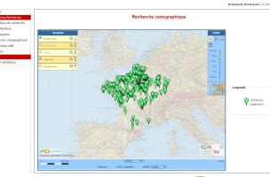
Recherche cartographique. S’ouvre une carte représentant, par défaut, l’ensemble des entités publiées dans la base sur fond de carte IGN.
© Base enquête Fer, Inrap, 2016
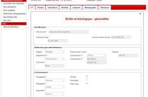
Fiche de présentation d'une entité archéologique : extrait onglet "Généralités".
© Base enquête Fer, Inrap, 2016

Fiche de présentation d'une entité archéologique : extrait onglet "Phases".
© Base enquête Fer, Inrap, 2016
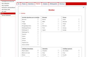
Fiche de présentation d'une entité archéologique : extrait onglet "Mobilier".
© Base enquête Fer, Inrap, 2016

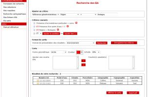
Formulaire de recherche des entités archéologiques. Choix d'un groupe de critères.
© Base enquête Fer, Inrap, 2016
ADVANCED FUNCTIONS: COMBINING SURVEYS, SPATIAL ANALYSES
The single or combined surveys proposed by the tool constitute the initial level necessary to realize searches. This search can be done using an advanced search form or a map search.
The data in the database can also be exported and integrated into an external geographic information system (GIS). For all sites, the X and Y geographic coordinates are recorded, or by default, the centroid of the commune (precision of the degree of reliability of the coordinates).
This system also permits combined searches integrating archaeological data with environmental layers (geomorphology, hydrography, geology, etc.). It is thus possible to calculate inter-site distances, their proximity to a water source, their co-visibility, and all else that is needed to perform a spatial analysis. In this case, the GIS resembles a geographic database (Malrain et al., 2010).
The aim is to better define sites, their function and their relations, as well as the space in which they existed.
DATA EXPLOITATION
The homogeneous recording of information enables the realization of diverse searches with no scientific predeterminations. This permits research directions to emerge with no biases, as is too often the case in archaeology. In addition, the field of investigation opened by the composition of this corpus is vast. The first phase of exploitation of these data has proven to be positive, as attested by the papers presented at the 32nd AFEAF colloquium (Bertrand et al., 2009).
The advanced functions of the database (combination of excavation data with the results of environmental, spatial and statistical analyses) have contributed to the development of various projects. These projects are both multidisciplinary (archaeology, palynology, carpology, etc.) and inter-institutional (Inrap, CNRS, Ministry of Culture and Communication, universities). These collaborations have resulted in the writing of syntheses concerning the management of a region, throughout the Second Iron Age, in relation to the means of production and the environment. The integration of archaeological, bioarchaeological (carpology, palynology) and climatic data with this work today enables a better understanding of their interactions (Blancquaert et al., 2012).
The on-line availability of the database facilitates the use of a large quantity of documentation by archaeologists in France and Europe (presentations in the framework of international colloquia). Several university theses based on the data of this national survey have already been realized (5 doctorates, 7 masters), along with numerous scientific publications (41, including 1 book and 4 articles in non-French reviews). The database is now well known and an increasing number of researchers and students request access to it, as both contributors and simple users.
We must remember that when using this tool, which can always be improved, one must retain a critical eye since, in addition to information that may be truncated due to erosion processes and the differential preservation of remains, excavation and research strategies can create biases that must be taken into consideration when using the data.
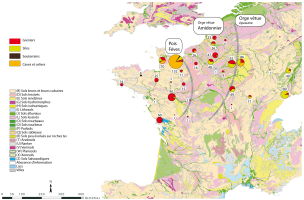
Enquête âge du Fer : carte pédologique et indices carpologiques.
Les infrastructures des sites, les espèces cultivées et l’outillage sont adaptés aux potentiels des sols.
Carte : © F. Malrain (Inrap), T. Lorho (SRA Bretagne), Zech-Matterne (CNRS). L'habitat rural du second âge du Fer. Recherches archéologiques 7, 2013
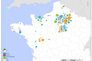
Répartition des structures de stockage dans le nord-ouest de la France entre le Ve et le IIIe siècle avant notre ère. On relève des spécificités régionales comme des souterrains en Bretagne, des fosses quadrangulaires en Normandie et davantage de silos et de greniers en Picardie et Île-de-France .
© T. Lorho (SRA Bretagne), S. Bossard (Université de Nantes), F. Malrain (Inrap), 2016
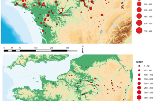
Enquête âge du Fer : durée d'occupation des sites.
Sur ces cartes qui traduisent les installations originelles (a) suivies d’une réoccupation au même emplacement (b), on remarque que l’ouest est moins affecté par ce phénomène. Les sites y connaissent une durée de vie plus longue.
© T. Lorho (SRA Bretagne), F. Malrain (Inrap) . L'habitat rural du second âge du Fer. Recherches archéologiques 7, 2013
EXAMPLE OF A RESEARCH TOPIC
In 2008, research was undertaken on a topic that chosen among several possibilities. This was to study the rhythms of the creation and abandonment of rural establishments, as was initiated by Pierre Nouvel at the Chauvigny scientific meeting (Nouvel et al., 2009).
The northern half of France was selected due to its greater quantity of documentation. One of the aims was to quantify the density of sites per chronological phase throughout the Second Iron Age. The expected results concerned the stability, progression or decrease in the number of occupations. The task was to reveal breaks or continuities: data that determine the mode of organization of a region and address issues concerning the demography. The comparison of varied regions and heterogeneous topographic contexts were expected to reveal similarities and differences in the rhythms at different spatial scales: micro-zones, departments, regions, inter-regions, southern France.
Because the current administrative regions do not correspond to the Protohistoric entities, it was also necessary to proceed based on an artificial division of the region in the form of a 50 km2 grid.
This exercise permitted an integration of the results with the historic and cultural context in function of the broad research themes on the European Iron Age. An initial version was sketched out at the round table held on October 7 and 8, 2009, in Rennes. The theme was concluded in 2013 with the publication of L’habitat rural du second âge du Fer. Rythmes de création et d'abandon au nord de la Loire dans la collection Recherches archéologiques (Malrain et al., 2013).
PERSPECTIVES FOR 2016
Operating in the domain of the social sciences, our knowledge is continually enriched and updated. It is therefore essential for this project, and the research tool that it has produced, to continue in the long-term. With the Inrap scientific and technical directorate, and the information systems directorate, as well as the AFEAF administrative committee, we are making every effort to enlarge the community of users of this on-line tool
REFERENCES CITED (in french) :
MALRAIN (F.) dir., BLANCQUAERT (G.) dir., LORHO (T.) dir. — L'habitat rural du second âge du Fer. Rythmes de création et d'abandon au nord de la Loire. Paris : CNRS Éditions, Inrap, 2013, 264 p. (Recherches archéologiques)
MALRAIN (F.), BLANCQUAERT (G.), LORHO (T.), MÉNIEL (P.), MATTERNE (V.), LEROYER (Ch.). — Un outil pour le renouveau des études sur le monde rural de l’âge du Fer en France. La base de données associée à un SIG. Archéopages 27, Paris : Inrap, 2009. 2010, p. 68-77.
BERTRAND (I.) dir., DUVAL (A.) dir., GOMEZ DE SOTO (J.) dir., MAGUER (P.) dir. — Les Gaulois entre Loire et Dordogne. Habitats et paysages ruraux en Gaule et regards sur d'autres régions du monde celtique : actes du 31e colloque international de l’AFEAF, 17-20 mai 2007, Chauvigny (Vienne). Chauvigny : Association des publications chauvinoises, 2009, 541 p. (Mémoires XXXIV et XXXV).
BLANCQUAERT (G.), LEROYER (Ch.), LORHO (T.), MALRAIN (F.), ZECH-MATTERNE (V.). — Rythmes de créations et d’abandons des établissements ruraux du second âge du Fer et interactions environnementales. In : BERTONCELLO (F.) éd., BRAEMER (F.) éd. — Variabilités environnementales, mutations sociales. Nature, intensités, échelles et temporalités des changements : actes des XXXIIe rencontres internationales d’archéologie et d’histoire d’Antibes. Antibes : Éditions APDCA, 2012, p. 233-245.
NOUVEL (P.), BARRAL (Ph.), DEFFRESSIGNE (S.), RIQUIER (V.), SÉGUIER (J.-M.), TIKONOFF (N.), ZEHNER (M.), ACHARD-COROMPT (N.) collab., BARTHÉLÉMY (D.) collab., DROUET (C.) collab., MOREAU (C.) collab., RAMPONI (C.) collab., VIDEAU (G.) collab. — Rythmes de création, fonctionnement et abandon des établissements ruraux de la fin de l’âge du Fer dans l’Est de la France. In : BERTRAND (I.) dir., DUVAL (A.) dir., GOMEZ DE SOTO (J.) dir., MAGUER (P.) dir. — Les Gaulois entre Loire et Dordogne. Habitats et paysages ruraux en Gaule et regards sur d'autres régions du monde celtique : actes du 31e colloque international de l’AFEAF, 17-20 mai 2007, Chauvigny (Vienne). Chauvigny : Association des publications chauvinoises, 2009, p. 109-151. (Mémoires XXXIV et XXXV).
Bibliography on the topic (in french)
Publications, studies and presentations resulting from the investigation (in french)
François Malrain
Inrap Nord-Picardie
UMR 7041 « Archéologies et sciences de l’Antiquité »
francois.malrain [at] inrap.fr
Thierry Lorho
MCC - DRAC-SRA Bretagne
UMR 6566 « Centre de recherche en archéologie, archéosciences, histoire »
thierry.lorho [at] culture.gouv.fr
Geertrui Blancquaert
MCC - DRAC-SRA Grand Est
Pôle patrimoines
geertrui.blancquaert [at] culture.gouv.fr
Inscription à la base de données (pour contribution ou simple consultation) :
recherche [at] inrap.fr


